Calling the Wildfire Management Community: Let’s Move Megafires From News Headlines to History Books
When the evening approaches and a day of combating wildfires comes to an end, it is often only the start for emergency services. They have to keep fighting the blaze that threatens their communities and nature, even during nighttime.
But what if the wildfire management community had the technology to detect wildfires while they are as small as a fire truck, and way before they grow and get out of control? OroraTech customers are already gearing up and pre-booking the 3-minute-detection constellation-based Wildfire Solution, which will revolutionize the data processing time and save millions in yearly costs of firefighting and detection.
Four Years of Processing and Analyzing Satellite Data for Wildfire Detection
Our current data is used by wildfire management professionals around the world. They’ve told us that smoke plumes often reduce performance and disable the on-ground cameras or aircraft monitoring capabilities, making it difficult to trace the fire direction, spreading speed, and giving the blaze enough time to grow to a dangerous size.
This is where satellite imagery enters the game – clear visibility through the smoke is only possible from space. Thermal infrared technology is one of the most effective methods for detecting heat through smoke. For nearly four years now, we’ve been processing satellite data from 20+ sources, including our in-house developed thermal-infrared camera FOREST-1, and incorporating it into our Wildfire Solution platform. This has helped us observe fire behavior and find solutions to tackle fires of different sizes and emergency stages effectively.
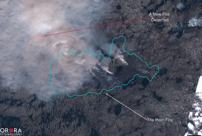
We’ve seen experienced firefighting services across the globe dealing with small fires with different but very effective techniques, almost in an automatized way. Fires detected at an early stage are less likely to grow larger and cause significant damage to human lives, nature, and properties.
It’s often the case though that small fires don’t get detected early enough to react on time. The current satellites providing data for wildfire detection depend on ground stations. Each satellite must first pass a ground station to transmit the data after detecting a hotspot. The data processing pipeline doesn’t stop there, and it might take up to 90 minutes to receive the first fire alert on the ground.
No Time to Lose – Megafires Need to Become History
At OroraTech, we understand the crucial role of technology in preventing wildfires from getting out of control. That's why we are developing innovative solutions that help detect these fires at their earliest stages and quickly alert emergency services, moving mega-fires as we know them today from the newspapers to history books.
According to our calculations, on average, our Wildfire Solution showed a 97% reduction in annual expenditures on fire detection compared to more traditional solutions like aeroplanes. It has also delivered one million dollars in cost savings per each fire contained at an early stage before the hotspot grows into a large fire of 50 hectares and more.
Our data specialists have engineered an algorithm that dramatically speeds up on-orbit data processing. This innovative solution compacts the critical fire information into a data package, which is then swiftly transmitted to Earth via an inter-satellite link. As a result, our Wildfire Solution users get notified within minutes after a fire event is detected, providing them with ample time to respond and prevent the blaze from spreading out of control.
On-orbit processing capabilities are just one part of the story. We plan to deploy our unique camera technology for the first OroraTech constellation launched by 2024. Designed specifically to cover the peak wildfire burn period in the afternoon, our constellation will fill the gap left by current satellite technology, which primarily captures fire data in the morning or evening.
The OroraTech Path to the 3-Minute Fire Detection
So how do these technologies work together to benefit wildfire management worldwide? Everything starts with the launch of our first satellite constellation (yes, there will be more launches soon!). As soon as all eight thermal infrared cameras start flying in their designated orbit, the scanning of Earth begins.
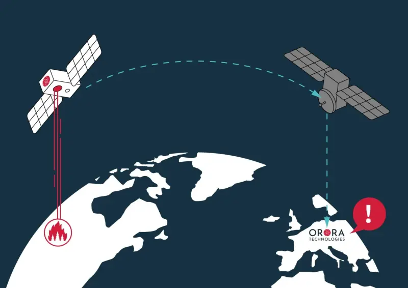
Our fire detection algorithm recognizes temperature anomalies as small as 4×4 meters. This data gets compressed and then transmitted to us via Inter-Satellite-Link. At the last step, customers get a fire alert via e-mail or WhatsApp, allowing them to proceed with fire assessment and monitoring via our Wildfire Solution platform. All of this will happen within 3 minutes after the satellite surpasses the affected area.
Do you want to learn more about our future constellation?