OTC-P1 proving early detection in the real world: the Laveno Fire
OTC-P1 proving early detection in the real world: the Laveno Fire
Early wildfire detection only matters if it’s trusted through testing. After months of development, calibration, and testing, our proprietary constellation OroraTech Phase-1 (OTC-P1 ) is delivering operational data to more and more users.
Beta access is currently available only to select customers and partners, but recent wildfire activity in Laveno Monbello, Italy, provided an early example of the system delivering value under real-world conditions.
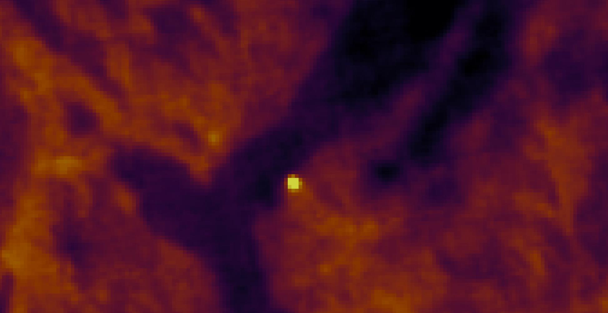
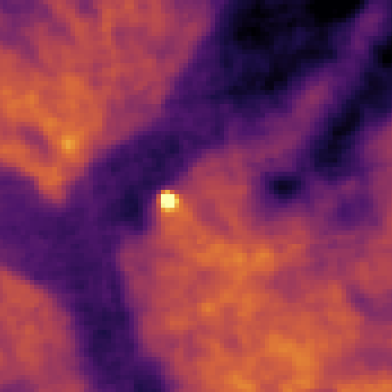
FOREST-09, a satellite of our OTC-P1 constellation, was the first LEO satellite to detect the fire in April, at 15:28 UTC. The fire was confirmed by AQUA 15 minutes later, followed by further confirmation from Meteosat-12 at 17:00 UTC.
During the incident, analysts working within the Rapid Mapping component of the Copernicus Emergency Management Service (CEMS), as part of a pilot activity under the Copernicus Contributing Missions (CCM) framework, evaluated wildfire detections using multiple sensor sources - including satellite data from our OTC-P1 constellation.
This represented an important operational test under challenging conditions, demonstrating how OTC-P1 data can support timely and accurate wildfire detection and situational awareness during active incidents.
For OroraTech, moments like this represent more than system performance. OTC-P1 is beginning to move from development into operational use by real customers and emergency stakeholders.
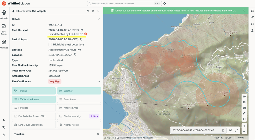
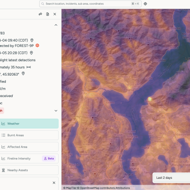
On April 4, a wildfire broke out near Laveno Mombello, north of Milan and close to Ispra. The fire covered roughly two hectares under difficult environmental conditions. Dry air, strong winds, and an orange fire risk alert contributed to rapid uphill fire movement through complex terrain while emergency response teams worked to contain the spread.
For wildfire agencies, these are exactly the conditions where early detection becomes both hardest and most valuable.
Smaller fires in rugged landscapes can escalate quickly, while smoke, terrain shadows, and changing atmospheric conditions make reliable detection more difficult. Detecting these incidents early - and with confidence - can directly influence response effectiveness.
Detection That Matched Reality
During the incident, wildfire detections from multiple satellite systems were evaluated together, including observations from FOREST-09 (a single satellite within our OTC-P1 constellation of eight satellites).
Within the CEMS Rapid Mapping pilot activity, the detections aligned closely with the wildfire activity observed during the incident. FOREST-09 delivered the first detection, while cross-sensor agreement with additional satellites helped confirm the hotspot as a real active fire rather than noise or a false alarm.
That distinction is critical in operational wildfire monitoring. Detecting a hotspot is not enough. Systems must detect the right fire, at the right location, and at the right time — with enough confidence for emergency services to trust the information operationally.
The Laveno incident demonstrated several important points simultaneously:
Early detection capability in complex terrain
Cross-sensor consistency
Strong cross-sensor agreement during a live incident
Operational relevance during a live incident
Most importantly, this was not a simulation or an internal benchmark exercise. The incident provided an opportunity to assess OTC-P1 detections against real wildfire activity and other operational sensor systems in near real time.
OTC-P1 Is Moving Into Operational Use
OTC-P1 data is now entering the hands of select operational users through an early-access beta program. For the constellation, this marks an important transition: moving from development and internal validation toward real-world usage by agencies and organizations responsible for monitoring active fire events.
Among the early users are teams connected to the Copernicus Emergency Service ecosystem, where analysts are already evaluating how FOREST constellation data can complement existing wildfire detection workflows.
The Laveno incident provided one of the first visible examples of that transition in practice.
Even at this stage, the data proved:
operationally relevant,
strong agreement across multiple sensor systems,
and actionable during a live incident.
Rather than testing performance in isolation, users were able to compare OTC-P1 detections directly against real fire activity and other operational sensor systems.
That represents an important step toward broader customer availability.
From Data Availability to Trust
The wildfire sector does not need more data for the sake of data. It needs information that emergency responders can trust under operational pressure. That trust is not built through marketing claims or controlled demonstrations. It is built through real incidents, independent validation, and reliable performance in the field.
The pilot activity within the CEMS Rapid Mapping context is intended to explore how commercial thermal wildfire observations can help improve the timeliness and accuracy of wildfire analysis during rapidly evolving fire events. By combining OTC-P1 detections with existing operational data sources, analysts can evaluate how additional thermal intelligence may support emergency mapping workflows.
The Laveno fire represents one of the first real-world examples of OTC-P1 contributing to operational wildfire analysis within a live emergency-mapping context.