OTC-P1 wildfire first detection review - July 2026
OTC-P1 wildfire first detection review - July 2026
If you follow our LinkedIn page, then you probably have already seen it: a steady stream of first detections and video content from OTC-P1. The constellation is now running across specific customer areas worldwide, and we're opening it to more areas every month. It's already proving what this constellation can do.
Satellite-based wildfire detection has always struggled with timing. Public satellites have gaps in daily coverage, including a well-known afternoon gap, right when fire conditions often peak. OTC-P1 is starting to close that gap. We're receiving thermal data at times when other satellites aren't overhead. In several cases, that meant we saw wildfires before public satellite systems did.
Here are a few examples. They're a small slice of what OTC-P1 is doing. Behind them, new hotspots, clusters, and detections feed directly to first responders around the clock.
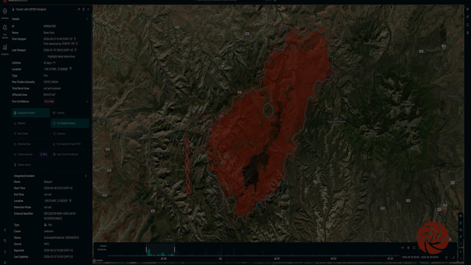
Babylon Fire, Utah, USA - June 27, 18:42 MST
On June 27, OTC-P1 detected a large wildfire near Bears Ears National Monument in Utah. A lightning strike near the Dark Canyon Wilderness started the fire, in some of the most remote terrain in the region.
As of August 7, crews haven't fully contained the fire, though it's no longer growing. Our Wildfire Solution estimates the fire has affected approximately 168,368 acres (68,136 hectares) - about 263 square miles (681 square kilometers).
Remote fires like this one make early information critical. OTC-P1 gave us a view from orbit and got that information to people on the ground.
Matthew Creek Fire, British Columbia, Canada - July 18, 18:44 MST
On July 18, OTC-P1 detected the Matthew Creek Fire near Fernie, British Columbia, a mountain resort town surrounded by dense forest and rugged terrain. The fire later became part of the larger Bootleg Complex as other fires ignited nearby.
As of August 7, we're still detecting new hotspots there, which means parts of the fire remain active. We estimate an affected area of approximately 10,535 acres (4,261 hectares), or 16.4 square miles (42.6 square kilometers).
The terrain here is rocky and mountainous, which makes ground-based monitoring difficult. That's where a view from orbit helps.
Rock Fire, California, USA - July 20, 2026
The Rock Fire started near the eastern boundary of Kings Canyon National Park in California. OTC-P1 detected it on July 20 as it burned through the region. This fire was started in a camera blind spot, making normal detection difficult - but not with OTC-P1 on overwatch.
By August 3, Cal Fire reported the fire 100% contained and lifted all evacuation orders and warnings the same day. Our Wildfire Solution estimates the Rock Fire affected approximately 14,812 acres (5,994 hectares), around 23.1 square miles (59.9 square kilometers).
This is what we built OTC-P1 to do: add more observations, at more useful times, so wildfire teams get a fuller picture of what's happening on the ground.
Avila - El Barraco fire in Spain - July 20th
On July 20, a broke out near Brieva, in neighboring Segovia province. Two days later, another ignited near Almorox in Toledo and spread into Villa del Prado, in the Community of Madrid. The fires merged into a single complex spanning three provinces, damaging forestry, protected natural areas, roads, power lines, and water infrastructure, and forcing evacuations.
On July 23, Spain's Ministry of Interior requested Copernicus EMS Rapid Mapping support for the complex. While we did not have first detections on either of these fires due to the speed of GEO satellites, we fed OTC-P1 thermal data into that effort, supporting the damage assessment used by Spain's national emergency center, CENEM.
Our Wildfire Solution estimates the complex has burned approximately 87,446 hectares (216,083 acres), or about 337.6 square miles (874.5 square kilometers). That makes it one of the largest fires OTC-P1 tracked this season.
A week Over Greece - July 20, 2026
In Greece, we support the Hellenic Fire Brigade directly through the Ministry of Digital Governance and Hellenic Space Center with thermal intelligence from both the dedicated Hellenic Fire System and OTC-P1. Thermal imagery from OTC-P1 the week of July 20 shows how often we observe Greece from orbit, and this sample doesn't even capture every overpass. More overpasses mean more chances to catch new fires, spot emerging hotspots, and track how existing fires change between observations.
Greece is one example. OTC-P1 generates this kind of data across our monitored areas worldwide.
Still in beta, but already moving the needle
These examples don't come close to the complete list of OTC-P1 first detections. In July, OTC-P1 alone contributed 14% of the total wildfire data in the areas we cover, combined with all public thermal satellite sources like NOAA, Meteosat, and Landsat. That 14% covers only OTC-P1. It doesn't include data from FOREST-2, FOREST-3, or the Hellenic Fire System.
OTC-P1 only recently entered beta, and it's already filling observation gaps, delivering detections at valuable times of day, and putting more thermal data into firefighters' hands worldwide. That's why we build these constellations - purpose built satellites to make a real difference on the ground. .
The future of wildfire detection isn't one good satellite image. It's a constantly updated picture of what's happening on the ground, delivered to the people who need it as fast as possible. Our teams are working to open OTC-P1 to more areas, increase data throughput, and keep validating results.
For us at OroraTech, this is just the start.
Stay in orbit with OroraTech
Read more about us