Meet MeteoSat-12: The Geostationary Satellite Giving Firefighters a Head Start
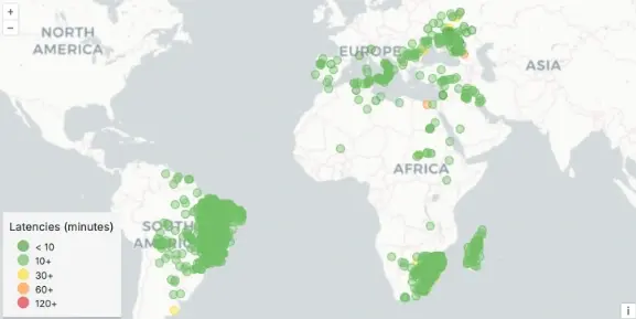
During a wildfire emergency, we have learned that more data equals better decision-making - if you don’t have the complete, up-to-date picture of the fire, how can you effectively fight it? That’s where our newest satellite, MeteoSat-12, in our FOREST network comes in. This geostationary sensor is a powerful new tool integrated exclusively into OroraTech’s Wildfire Solution, and it's already making a measurable difference across Europe, South America, and Africa.
Supporting our Near-Real-Time Fire Detection Mission
MeteoSat-12 is a geostationary (GEO) satellite, meaning it orbits the Earth at the same rate the planet rotates, providing constant surveillance over specific regions. What sets it apart is not its position but its speed - MeteoSat-12 scans every 10 minutes, with data latency in just 15 minutes. Because the satellite is constantly observing, near-real-time monitoring is achieved with earlier alerts and therefore fast responses, potentially saving lives and millions in damage.
GEO satellites are great for early detection because they constantly see one area. However, to achieve that sort of orbit, the satellites need to be incredibly far away from the planet - 35,786 kilometers (22,236 miles) on average. Being able to see detail from this distance is incredibly difficult, with the ground sample distance (how much area of Earth that each pixel of an image covers) of a typical thermal GEO satellite being between 2-5 km wide. This means fast detections, but not a lot of detail in those detections.
What makes MeteoSat-12 different from other GEO satellites is its ground sampling distance of only 1km, with the unmatched ability to detect fires as small as 50 x 50 meters (164 feet x 164 feet). That’s a significant improvement. Being able to spot smaller fires faster, before they grow out of control, means helping spot smaller fires before they grow into large-scale disasters.
Real-World Impact: August 2025 Wildfire Activity
In August 2025, during peak wildfire activity in Europe and Brazil, MeteoSat-12 accounted for 41% of our first detections across major wildfire clusters in Europe and 29% in Brazil — rivaling even long-established instruments like VIIRS and GOES-19.
This performance proves that MeteoSat-12 surpasses the performance of typical GEO satellites, making it an incredibly valuable asset for our FOREST global fire detection ecosystem.
For wildfire response agencies and policymakers, the benefits are clear:
Earlier warnings = faster mobilization of fire crews
More accurate fire behavior insights = better resource allocation
Coverage across continents = less reliance on fragmented data sources
And because OroraTech has exclusive integration, users of its Wildfire Solution get access to tools and insights unavailable anywhere else.
Exclusive Integration with OroraTech’s Wildfire Solution
Here’s something no other wildfire platform can offer: OroraTech is the only company integrating MeteoSat-12 data with the new FRP-PIXEL product from the Satellite Application Facility on Land Surface Analysis (LSA SAF), part of the European Organization for the Exploitation of Meteorological Satellites (EUMETSAT). This new algorithm gives OroraTech users access to Fire Radiative Power (FRP) from a GEO satellite - a key measure of how intensely a fire is burning.
In simpler terms, this means OroraTech customers don’t just see where a fire is - they get a clearer picture of how dangerous it is. A small, smoldering brushfire and a raging, fast-moving wildfire might look similar from basic GEO data, but FRP-PIXEL helps distinguish between the two by showing how much heat the fire is putting out.
That matters because a hotter fire usually spreads faster and is harder to contain. With this kind of real-time intensity data, fire crews can focus their efforts on the biggest threats first, potentially stopping major fires before they spiral out of control. It also helps officials make smarter choices about when to issue evacuation alerts, where to send aircraft or ground teams, and how to plan for the next 12–24 hours of fire behavior. In an emergency, this kind of clarity can save both lives and resources.
Filling the Afternoon Detection Gap
We have made a big deal about the Afternoon Detection Gap before, highlighting that it's one of the hardest challenges with satellite-based wildfire detection. Because low Earth orbit (LEO) satellites only pass during a certain time of the day, many public satellites aren’t built specifically for wildfire; they tend to clump together at certain times - usually around 10am/10pm, and 1pm/1am.
As we continue to prepare our OTC-P1 (Pine Grove) constellation for commercial use, MeteoSat-12 closes this gap by delivering high-frequency data exactly when it's needed most. Because the satellites are constantly watching a dedicated area, there is no need to worry about time. The satellite sees, detects, and transmits data on Europe, South America, and Africa, no matter the time of day.
A single wildfire tool: Wildfire Solution (WFS)
MeteoSat-12 is seamlessly integrated into OroraTech’s Wildfire Solution, which fuses data from both geostationary satellites like MeteoSat-12 and polar-orbiting LEO satellites FOREST-2, VIIRS, Terra, and Aqua.
This matters because the two types of satellites see the world in different ways. While GEO satellites stay stationary, as mentioned above, polar-orbiting LEO satellites sweep the globe in detailed passes, offering high-resolution snapshots from multiple angles, ideal for assessing fire perimeter and landscape impact. By combining both perspectives into one operational dashboard, OroraTech gives fire managers the best of both worlds: real-time alerts with rich details, all in a single interface that’s easy to use during high-pressure moments.
No switching tabs. No cross-referencing different tools. Just one unified, intelligent system that helps emergency teams move from detection to action in record time.
The Bottom Line
MeteoSat-12 is currently the best GEO satellite for wildfire detection - period. From its high-frequency scanning and unmatched fire sensitivity to its integration with FRP-PIXEL and role in closing critical afternoon detection gaps, it gives wildfire responders a powerful edge in the moments that matter most.
Combined with OroraTech’s unified Wildfire Solution platform, MeteoSat-12 transforms data into decisions. Fire crews aren’t just alerted earlier, they’re equipped with deeper insights, clearer priorities, and greater confidence when every second counts.
As climate-driven fire seasons intensify, agencies need more than just more data. They need the right data, at the right time, in the right format. That’s exactly what MeteoSat-12 delivers. It’s already proving itself across some of the world’s most wildfire-prone regions.
In the fight against wildfires, speed, clarity, and accuracy save lives. And with MeteoSat-12, all three just got a major upgrade.
The product is provided by the EUMETSAT Satellite Application Facility on Land Surface Analysis (LSA SAF; Trigo et al., 2011)
http://lsa-saf.eumetsat.int
Trigo, I. F., C. C. DaCamara, P. Viterbo, J.-L. Roujean, F. Olesen, C. Barroso, F. Camacho-de Coca, D. Carrer, S. C. Freitas, J. García-Haro, B. Geiger, F. Gellens-Meulenberghs, N. Ghilain, J. Meliá, L. Pessanha, N. Siljamo, and A. Arboleda, 2011: The Satellite Application Facility on Land Surface Analysis. Int. J. Remote Sens., 32, 2725-2744, doi: 10.1080/01431161003743199"